Les North York Moors sont un mélange de landes de bruyère accidentées, de vallées isolées, de creux boisés et de côtes spectaculaires : la destination idéale pour les amateurs de solitude.
1er mars 2025 | Paroles de Joly Braime @ WildBounds HQ
Couvrant plus de 550 miles carrés, le parc national des North York Moors est un mélange de landes de bruyère accidentées, de vallées isolées, de creux boisés et de côtes spectaculaires. Relativement peu élevé par rapport à d'autres parcs nationaux, il est également beaucoup plus calme. Les inévitables lieux de prédilection sont peu nombreux et éloignés les uns des autres, et il est très facile de sortir des sentiers battus.
Et sortir des sentiers battus est en grande partie l'objectif de cette région. Les North York Moors n'ont pas les réseaux de grottes des Yorkshire Dales ni les vastes possibilités d'escalade du Peak District, et les rivières ne sont pas assez grandes ou spectaculaires pour permettre la pratique de sports de pagaie. En revanche, ce parc particulier regorge de sentiers pédestres, de pistes de VTT et de routes de campagne sinueuses pour le cyclotourisme.
Les chaussées balisées suivent souvent d'anciennes routes de cadavres et des chemins de drave à travers les landes.
La plupart du temps, vous n'aurez pour seule compagnie que les moutons et les oiseaux - les alouettes des champs et les courlis, les tétras lyres et les vanneaux toujours de mauvaise humeur. Vous pourrez peut-être apercevoir des chouettes effraies chassant le long des clôtures, des dauphins et des fous de Bassan plongeant dans les baies, ou le dos diamanté d'une vipère prenant un bain de soleil à l'air libre.
Outre la beauté naturelle et la faune, le statut de parc national de la région protège également un riche filon d'histoire humaine. Vous y découvrirez des tumulus de l'âge du bronze, des camps romains abandonnés, des pierres médiévales, des voies ferrées désaffectées et les vestiges de l'exploitation minière de la pierre à fer et de l'alun. Au XXe siècle, la côte du Yorkshire et les landes avoisinantes ont été dominées par l'armée, laissant derrière elle les vestiges en ruine de bunkers, de stations radar et de champs de tir.
Tout cela, et bien d'autres choses encore, ne demande qu'à être découvert - et la meilleure façon de le faire est de se munir d'une carte OS, de tracer un itinéraire et de s'enfoncer dans la bruyère.
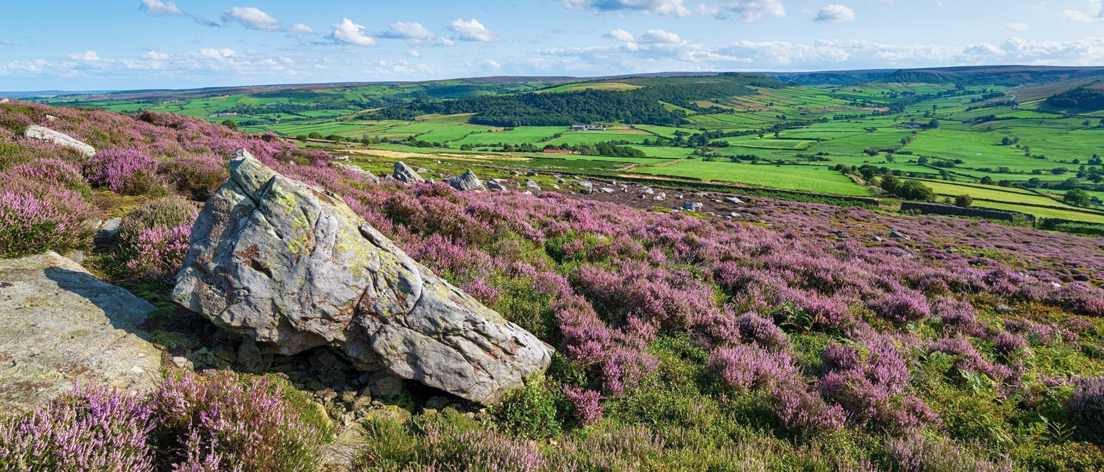
Paysages de landes dans le coin sud-est du parc national des North York Moors.
Orientation
Centrées autour d'un plateau de landes découpé par de profonds vallons, les North York Moors se trouvent sur la côte nord-est du Yorkshire, au nord de York (l'indice est dans le nom) et au sud de la région industrielle de Teesside.
Les bords nord, sud et ouest du parc sont délimités respectivement par les Cleveland Hills, les Tabular Hills et les Hambleton Hills. Si vous préférez penser en termes de routes, cela correspond à peu près à l'A171/172 au nord, à l'A170 Scarborough road au sud et à la très fréquentée A19 à l'ouest. La frontière orientale est facile à tracer, puisqu'il s'agit de la mer du Nord.
En fait, les landes sont assez bien définies, car elles se trouvent sur une grande plate-forme inclinée de roche jurassique (grès au nord et calcaire au sud), et sont entourées d'un pays beaucoup plus plat. La vaste vallée de Mowbray se trouve à l'ouest et la vallée de Pickering au sud, avec les plaines de Teesside au nord. Une randonnée dans les collines de Cleveland par temps clair donne l'impression de marcher sur les remparts nord du parc national, offrant des vues spectaculaires sur la plaine en direction des cheminées et des parcs éoliens de Middlesbrough et de Redcar, autrefois puissant centre de l'industrie sidérurgique britannique.
À l'intérieur du parc national, la principale vallée est Eskdale, qui mène à la côte de Whitby (techniquement non incluse dans le parc, et donc plus développée). Parmi les autres vallées notables, citons Farndale et Rosedale (célèbres respectivement pour leurs jonquilles printanières et leurs vestiges industriels), mais il en existe plusieurs autres, chacune ayant son propre caractère.
Lever de soleil sur la jetée de Whitby.
Pour des cartes détaillées, les feuilles OS Explorer OL27 et OL26 couvrent les côtés est et ouest des North York Moors. À plus petite échelle, la majeure partie du parc national est incluse dans la feuille OS Landranger 94, mais vous aurez besoin des numéros 100 et 93 pour la partie ouest. La carte générale la plus utile de la région est la Harvey Maps 1:40 000 North York Moors British Mountain Map, qui a l'avantage d'être imprimée sur du polyéthylène imperméable plus durable.
Activités
Randonnée
Avec un réseau de 1 400 miles de sentiers publics - la plupart très bien entretenus - vous pourriez passer des années à explorer le parc national des North York Moors et il vous resterait encore beaucoup à découvrir. Une grande partie du parc est en accès libre, y compris de vastes étendues de forêt.
Les autorités du parc national sont très attentives aux droits de passage, ce qui signifie que les problèmes d'accès sont rares, mais une grande partie des terres est gérée pour la chasse au chevreuil ou au faisan, ce qui implique quelques mises en garde. La première est que votre carte n'est peut-être pas la plus fiable sur les landes ouvertes, où les droits de passage peuvent disparaître dans la bruyère et où les chemins qui existent sont souvent des chemins non cartographiés qui mènent à des cages à gélinottes ou à des stations d'épandage de gravier.
Deuxièmement, il y a pas mal de gardes-chasse dans les environs, donc si vous faites du camping sauvage, il y a de fortes chances que vous soyez déplacé. Ils sont généralement polis, mais il y a encore beaucoup de ressentiment à l'égard des campeurs sauvages après le boom du "fly-camping" post-Covid, et les gardes-chasse sont moins enclins à fermer les yeux qu'ils ne l'étaient autrefois.
Certaines promenades classiques sont répertoriées dans la section des points forts, mais il est facile de créer son propre itinéraire en le rattachant à l'un des sentiers de longue distance qui traversent le parc. Il en existe quatre principaux :
Le sentier nationalCleveland Way est le sentier longue distance phare du parc national des North York Moors. Il s'étend sur 110 miles, de Helmsley à Filey Brigg, via une large boucle qui passe par les landes et les vallons les plus prisés, ainsi que par une longue portion de la magnifique côte du Yorkshire.
Le Tabular Hills Walk, moins connu, est un itinéraire de 48 miles entre Scarborough et Helmsley, qui suit le plateau de collines calcaires à l'extrémité sud du parc national. Vous pouvez la combiner avec le Cleveland Way pour en faire une superbe promenade circulaire.
La Lyke Wake Walk a débuté dans les années 1950 sous la forme d'un défi de 24 heures sur 42 miles. L'idée était de traverser les North York Moors d'Osmotherley à Ravenscar, en restant dans les landes de bruyère et en évitant les vallées. Cette épreuve est depuis longtemps tombée en désuétude au profit de défis plus grammaticaux comme les Three Peaks, mais elle reste un itinéraire merveilleux et pittoresque, entouré de traditions plutôt étranges et d'une chanson qui lui est propre. Transformez cette épreuve en plaisir en la répartissant sur deux journées de 20 miles et en passant la nuit à la célèbre Lion Inn sur la crête de Blakey.
Le Coast-to-Coast de Wainwright termine sa traversée de 190 miles d'ouest en est au pub Bay Hotel de Robin Hood's Bay, et les 3-4 derniers jours traversent les North York Moors. Très populaire pendant les mois d'été, elle jouit d'une réputation internationale, un peu comme le West Highland Way, et vous verrez souvent des groupes de marcheurs commerciaux accompagnés de camionnettes de soutien. Les haltes de nuit comme le Lion Inn peuvent avoir une atmosphère agréable de camaraderie partagée. Sa transformation en sentier national, attendue depuis longtemps, devrait être achevée à la fin de 2025.
La célèbre épave de Saltwick Nab, vue depuis le Cleveland Way.
Cyclisme
Pour une raison inconnue, les North York Moors ne sont pas aussi fréquentées par les cyclistes qu'elles devraient l'être, en particulier ceux qui roulent sur l'asphalte. Guisborough et Redcar accueillent un nombre disproportionné de triathlètes et il peut y avoir pas mal de trafic de pédales dans ce coin du parc national, mais ailleurs les routes sont très calmes.
Ce qui est vraiment dommage, car cette partie du Yorkshire du Nord possède de magnifiques pistes cyclables. L'une des plus connues est la North York Moors Cycleway (171 miles), un itinéraire en forme de huit qui s'en tient aux routes secondaires et explore certaines zones excentrées, à côté de lieux très fréquentés comme Whitby, Helmsley et Hutton-le-Hole.
L'équivalent hors route est le Moor-to-Sea Cycle Network, qui relie des chemins forestiers, des voies vertes, des routes secondaires et des lignes de chemin de fer désaffectées en une série de boucles que vous pouvez enchaîner pour créer des itinéraires allant jusqu'à 150 miles. La piste cyclable des North York Moors et le réseau Moor-to-Sea sont tous deux accessibles depuis les lignes ferroviaires principales via l'Esk Valley Railway.
Pour les vététistes, l'essentiel de l'action se concentre autour de la forêt de Dalby et de Sutton Bank, mais il y a aussi des zones plus calmes. La forêt de Langdale, près de Scarborough, est un endroit populaire pour les randonnées à vélo, et l'ancienne voie ferrée Whitby-Scarborough est un lieu de prédilection pour les familles.
Si vous ne savez pas par où commencer, le Yorkshire Cycle Hub peut être une bonne idée. Niché au bout de l'impasse de Great Fryup Dale, il dispose de son propre bunk house et d'un café, ainsi que d'un magasin de vélos avec des mécaniciens certifiés Cytech.
Les soirs d'été, pagayez au large de la côte jurassique du Yorkshire.
Autres activités
Il n'y a pas que les bottes et les vélos, mais les activités proposées sont si nombreuses qu'il est difficile de les couvrir toutes.
Les North York Moors sont très fréquentés par les amateurs de course à pied, en particulier plus au nord, vers l'extrémité de Teesside. La piste cendrée de Whitby et la forêt de Dalby accueillent toutes deux des courses hebdomadaires, et des courses plus longues sont organisées tout au long de l'année, notamment la célèbre série Hardmoors.
Bien qu'il n'y ait pas la scène d'escalade des Peaks ou des Dales, il y a quelques zones attrayantes, principalement le long des falaises de grès à la limite nord du parc national. Le site le plus célèbre est celui des Wainstones (voir ci-dessous), avec de bonnes possibilités d'escalade sur les plus petites falaises de Scugdale (quittez l'A172 à Swainby et suivez la route quelques kilomètres plus bas dans la vallée). Ailleurs, vous trouverez souvent des grimpeurs à Highcliffe Nab, près de Guisborough.
La pêche en mer est une obsession sur la côte du Yorkshire - en particulier chez les adolescents et les hommes d'un certain âge - mais tout le monde peut participer à l'action. Il y a des marques de pêche sur le rivage tout le long de la côte et, en été, lorsque le maquereau est en pleine activité, vous verrez des dizaines de personnes filer au large des jetées de Whitby. La pêche en kayak est également populaire, en particulier dans les baies les plus abritées comme Sandsend et Runswick. Si vous êtes à la recherche d'un poisson plus gros, de nombreux opérateurs de bateaux organisent des sorties de pêche en mer.
Les bateaux locaux proposent également des excursions d'observation de la faune et de la flore, en particulier pendant la migration automnale des baleines, de fin août à novembre. Les baleines de Minke sont les plus courantes, mais il y en a d'autres, ainsi que des dauphins et des marsouins. Tout le monde espère le jackpot de la baleine à bosse, qui apparaît parfois.
La pêche à l'intérieur des terres se fait à l'aide d'un ticket journalier ou d'un permis saisonnier, généralement délivré par le bureau des domaines ou le club de pêche local. On peut pêcher du saumon et de la truite de mer dans la rivière Esk, ou pêcher du poisson grossier à bon marché dans les réservoirs de Scaling Dam et de Lockwood Beck.
La côte est propice au kayak de mer, avec quelques baies abritées pour les pagayeurs moins expérimentés. C'est un excellent moyen d'explorer certaines des criques les plus inaccessibles, et vous apercevrez souvent les vestiges d'anciennes mines de jais ou d'alun. Sandsend et Runswick sont également propices à la pratique du stand-up paddle board et, en été, les dauphins et les phoques viennent souvent dans les baies.
Les rivières sont moins profondes et moins propices au kayak ou au paddle board, bien que l'estuaire de l'Esk soit un peu plus fréquenté (prenez le départ à Coates Marine, près de la Co-op, et remontez le long du viaduc de Larpool jusqu'au barrage de Ruswarp). Il est possible de pagayer à la journée à Wykeham Lakes et Scaling Dam (vous pouvez acheter un abonnement à la journée lorsque la couverture de sécurité est en place), mais de nombreux pagayeurs ont tendance à se rendre sur la Tees pour des excursions sur la rivière à partir de Preston Park ou en eau vive au barrage de la Tees.
Le célèbre "bracelet de charme" de Richard Farrington, près de Saltburn sur le Cleveland Way.
Les meilleurs spots de surf sont une question controversée. Si les gens surfent à Whitby (et il y a une école de surf là-bas), les surfeurs plus expérimentés ont tendance à se diriger vers Cayton Bay, Scarborough ou Saltburn.
Il existe une forte tradition locale de chasse aux fossiles sur la côte jurassique du Yorkshire, et vous verrez souvent des cordes boulonnées dans les falaises (parfois, elles servent aussi à accéder aux marques de pêche, mais le diagramme de Venn des chasseurs de fossiles et des pêcheurs en mer se recoupe largement). Il y a beaucoup de bons endroits, mais les préférés sont Robin Hood's Bay, Saltwick Bay, Whitby (la partie rocheuse au sud des jetées) et la partie entre Sandsend et Kettleness. La région de Whitby est également un bon terrain de chasse pour le jais, un minéral noir semi-précieux qui faisait fureur à l'époque victorienne. Quelle que soit la nature de votre chasse, faites très attention aux marées, car il est très facile de se faire couper l'herbe sous le pied.
Baie de Robin des Bois
Points forts
Le trou d'Horcum
Selon la légende, cet impressionnant "punch du diable" a été créé par un géant qui a ramassé une grosse motte de terre pour la lancer sur sa femme. D'apparence glaciaire, il a en fait été formé par un processus progressif d'érosion par l'eau.
L'excursion classique consiste à faire le tour du Hole of Horcum, puis à descendre derrière lui jusqu'à un ancien pavillon de chasse en ruine appelé Skelton Tower. La tour surplombe le magnifique et lointain Newton Dale, et si vous arrivez à temps, vous aurez peut-être la chance de voir un train à vapeur serpenter le long de la vallée boisée.
Vue de Sutton Bank
Sutton Bank
Alf Wight - plus connu sous le nom de James Herriot, vétérinaire et auteur - estimait que la vue depuis le sommet de Sutton Bank était la "plus belle d'Angleterre". Dans les années 1940, le talus de 1 sur 4 était trop raide pour sa vieille Austin Seven, mais heureusement, la petite voiture était équipée d'une boîte de vitesses inférieure en marche arrière, de sorte qu'il pouvait à peu près la gravir en roulant à reculons.
Avec un moteur moderne, il n'y a pas de souci à se faire, et la vue est vraiment sensationnelle, avec une vue sur la vallée de Mowbray, les Pennines et les Yorkshire Dales.
De nos jours, Sutton Bank dispose d'un excellent centre d'accueil des visiteurs du parc national qui sert de plaque tournante pour les activités de plein air dans la région. On y trouve toute une série d'itinéraires balisés pour le VTT (classés de vert à rouge), ainsi que deux pistes cyclables spécialement aménagées et une station de lavage pour les vélos. Les sentiers autour du centre sont accessibles aux fauteuils roulants et vous pouvez également réserver des Trampers (scooters de mobilité tout-terrain).
Les Wainstones près de Great Broughton.
Les Wainstones et les Bridestones
Les North York Moors présentent deux zones principales de formations rocheuses. La première est une série d'escarpements de grès dans la partie nord-est du parc national, connue sous le nom de Wainstones. Ressemblant à une série de dents de dinosaures, elles attirent les grimpeurs locaux, et les vues étonnantes depuis l'escarpement de Cleveland permettent de faire de superbes randonnées. Vous pouvez vous garer (et camper) à proximité, au Lordstones Country Park, mais de nombreux randonneurs aiment aussi se garer à Chop Gate et parcourir un circuit de 8 miles environ le long des Wainstones.
Plus à l'est, les Bridestones sont une collection de sucettes de grès altérées dans la partie nord de la forêt de Dalby. C'est une promenade facile à partir des parkings de la forêt, mais vous pouvez aussi passer la journée à vous garer au Hole of Horcum et à visiter le Blakey Topping en chemin.
Mines de grès de Rosedale
Du milieu des années 1800 aux années 1920, Rosedale, isolé, était une énorme entreprise minière qui fournissait de la pierre à fer aux hauts-fourneaux de Teesside. Elle possédait même son propre chemin de fer à écartement standard qui traversait les landes jusqu'à Battersby Junction, près de Great Ayton.
Aujourd'hui, Rosedale est un endroit tranquille, mais il y a de nombreux vestiges industriels à explorer, notamment les célèbres fours de Chimney Bank. Vous pouvez marcher depuis le village de Rosedale Abbey ou vous garer sur la crête à Little Blakey. Pour une journée plus longue, l'ancienne voie ferrée est aujourd'hui une large piste cavalière de lande, que vous pouvez emprunter pour parcourir une boucle vivifiante de 14 miles autour de Farndale Head.
Les jonquilles de Farndale
Farndale est l'un des vallons les plus isolés du parc national des North York Moors, et il est très calme la majeure partie de l'année. Cependant, de la mi-mars à avril, la vallée se transforme en une mer de petites jonquilles indigènes, et les visiteurs affluent de tout le Yorkshire et au-delà pour profiter d'une promenade le long de la rivière Dove.
L'itinéraire standard de 3,5 miles commence sur le parking de Low Mill et suit la rivière jusqu'à Church Houses, puis revient. Si vous n'aimez pas revenir sur vos pas, il existe un autre itinéraire de retour qui remonte un peu plus haut dans la vallée.
La forêt de Dalby
Bien qu'elle ait été rebaptisée "la grande forêt du Yorkshire", la forêt de Dalby est une excellente excursion d'une journée. On y trouve des sentiers de randonnée, un centre d'accueil des visiteurs, des cafés et même un parcours dans les arbres (Go Ape), mais la plupart des gens sont là pour le VTT.
La forêt de 8 500 acres offre une gamme complète de pistes cyclables, depuis les routes pavées faciles jusqu'aux pistes très difficiles comme la piste noire de la Coupe du monde UCI.
L'accès à la forêt de Dalby est un peu particulier. Il est gratuit si vous n'arrivez pas en voiture (principalement parce qu'il est difficile de le faire), ou si vous ne faites que passer - ce qui signifie que vous devez entrer et sortir en moins de 20 minutes. Sinon, il suffit de se garer dans l'un des parkings et de payer à la sortie (frais de stationnement à partir de £3/h jusqu'à un plafond de £15 par jour, avec possibilité d'abonnement annuel). Tous les détails sur le site de Forestry England.
Pour une expérience un peu plus tranquille sans tous les équipements, la forêt de Langdale, près de Scarborough, est un autre bon choix pour les cyclistes.
La silhouette distinctive de Roseberry Topping.
Roseberry Topping
La silhouette proéminente de Mr Whippy de Roseberry Topping est l'une des caractéristiques les plus distinctives des North York Moors. On l'appelle parfois le "Cervin du Yorkshire" - non sans ironie, puisqu'il ne mesure que 320 mètres de haut. Mais ce qui manque à sa stature, il le compense par son charisme et ses superbes vues.
C'est un lieu de prédilection et, par temps normal, les routes et les chemins qui l'entourent deviennent rapidement sclérosés, les pistes étant tachetées de crottes de chien et de boîtes de conserve vides de Monster. Lorsque vous atteignez le sommet, l'air est souvent richement parfumé de nuages de jus de mangue, de fumée de mauvaises herbes ou de bonnes vieilles Marlboro.
Se plaindre de ces choses, cependant, c'est passer à côté de l'essentiel. Les North York Moors regorgent d'endroits où l'on peut trouver la paix et l'isolement, mais Roseberry Topping est un endroit où l'on peut apprécier d'être une personne parmi les autres. Toute la vie est là, des groupes d'adolescents de Teesside aux groupes familiaux de Leeds ou de Bradford. Un soir de l'été dernier, un groupe d'Érythréens filmait une vidéo politique avec une réplique d'AK-47.
C'est le genre d'endroit où l'on se demande en mariage, où l'on répand des cendres ou où l'on se contente de regarder le coucher du soleil.
Aspects pratiques
Où séjourner ?
De nombreux visiteurs s'installent sur la côte, en partie parce que tout le monde aime le bord de mer, mais aussi parce que les liaisons de transport sont meilleures. Les principales villes côtières sont Scarborough et Whitby, mais il y a aussi d'anciens villages de pêcheurs parfaits comme Runswick Bay, Staithes et Robin Hood's Bay (que les habitants appellent simplement "Bay").
Au sud, Pickering, Helmsley et Kirkbymoorside sont de jolies villes de marché qui constituent de bons points de départ pour explorer le parc national des North York Moors. Pickering, en particulier, se trouve à proximité de sites incontournables tels que le Hole of Horcum, la forêt de Dalby et le chemin de fer à vapeur des North Yorkshire Moors.
Le nostalgique chemin de fer à vapeur des North Yorkshire Moors offre également un moyen véritablement utile d'accéder aux coins reculés des landes.
La partie nord du parc national est généralement moins appréciée des visiteurs, mais Guisborough et Great Ayton sont deux villes attrayantes, bien desservies par les transports, et bien situées pour visiter des sites importants comme Roseberry Topping et le Captain Cook Monument.
À l'intérieur du parc national, certains des plus grands villages proposent des hébergements décents, notamment des pubs, des chambres d'hôtes et des campings. Hutton-le-Hole, Rosedale Abbey et Farndale sont très attrayants mais difficiles d'accès sans voiture. Pour ceux qui utilisent les transports en commun, Goathland (ou Aidensfield si vous êtes un fan de Heartbeat) dispose d'un service de bus régulier, tandis que la ligne de chemin de fer Esk Valley Railway dessert des villages plus importants comme Castleton, Danby, Lealholm, Glaisdale, Egton et Grosmont.
Camping-caravaning
Avec ses nombreuses aires de stationnement isolées, le parc national des North York Moors est l'endroit idéal pour amener un camping-car. Malheureusement, l'explosion de sa popularité a entraîné des interdictions de stationnement de nuit dans certains endroits très fréquentés du bord de mer. Au moment de la rédaction de ce rapport (février 2025), des interdictions de courte durée étaient en vigueur à Sandsend, Cayton Bay et sur le front de mer de Scarborough. Ces interdictions pourraient ou non devenir permanentes après une période de consultation de six mois.
Moutons marchant sur la route isolée de Spaunton Moor, juste au-dessus de Hutton Le Hole.
Se déplacer
Malheureusement, la voiture est toujours reine dans les North York Moors.
Le North Yorkshire a perdu une grande partie de son réseau ferroviaire dans les années 60, et les liaisons ferroviaires avec le reste du pays sont plutôt mauvaises. Pour accéder aux North York Moors par les lignes ferroviaires principales, les meilleurs points d'entrée sont Middlesbrough, Scarborough ou Malton. Ces trois villes disposent de bons services de bus vers d'autres villes et villages de la région, et Middlesbrough vous permet également de prendre le train Esk Valley Railway, utile mais peu fréquent.
La ligne de l'Esk Valley est un survivant improbable de la hache Beeching. Elle va de Boro à Whitby en passant par une série de petits villages de la lande. Elle peut être un peu "St Trinian's" si vous tombez sur un train scolaire, mais elle est aussi très prisée par les familles de Middlesbrough qui visitent la mer - et elle relie plusieurs villages d'Eskdale qui sont pratiquement inaccessibles par le réseau de bus.
Entre Pickering et Whitby, vous pouvez également emprunter le North Yorkshire Moors Railway. Cette ligne patrimoniale est équipée de locomotives à vapeur et de matériel roulant d'époque, mais elle assure également un service régulier pendant les mois d'été et dessert des villages assez isolés comme Grosmont, Goathland et Levisham. La halte de Newtondale est particulièrement appréciée. Il s'agit d'un arrêt de demande non surveillé au milieu des bois, idéal pour les randonneurs. Des panneaux sur le quai vous avertissent de faire attention aux vipères.
En ce qui concerne les bus, la plupart des lignes passent à proximité des landes. La route côtière entre Scarborough, Whitby et Middlesbrough est très bien desservie (horaires ici), et des centres comme Guisborough et Great Ayton sont bien desservis. À la limite sud du parc national, des endroits comme Kirkbymoorside et Helmsley sont un peu plus mal desservis par les transports publics, mais il est toujours possible de s'y rendre avec un peu d'anticipation.
Malheureusement, la combinaison de la géographie et de la viabilité économique signifie que les services de bus à l'intérieur des landes elles-mêmes sont inégaux ou inexistants. Entre juin et octobre, le service Moorsbus, géré par des bénévoles, couvre une variété d'itinéraires dans les landes, mais les bus sont peu fréquents et il faut planifier avec soin.
L'un des bus les plus utiles dans la région est le Coastliner (numéros 840 et 843). Il existe différentes permutations de l'itinéraire, mais il va de Leeds et/ou York à Whitby ou Scarborough, en s'arrêtant à Pickering, Thornton-le-Dale et même Goathland. Figurant souvent sur les listes des lignes de bus les plus pittoresques de Grande-Bretagne, ce service est régulier, pratique et incroyablement bon marché.
Où que vous séjourniez et quel que soit votre moyen de transport, les landes ondulantes, les vallons isolés et les côtes escarpées de cette partie du Yorkshire du Nord regorgent de secrets à découvrir et d'aventures à vivre. À bientôt...